To use PC*MILER for the AS/400, issue the command PCMILER (or PCMTLL for PC*MILER|Tolls) from the command line.
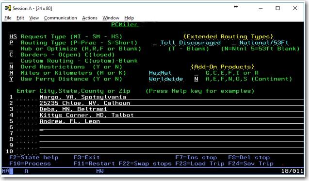
PC*MILER Main Screen
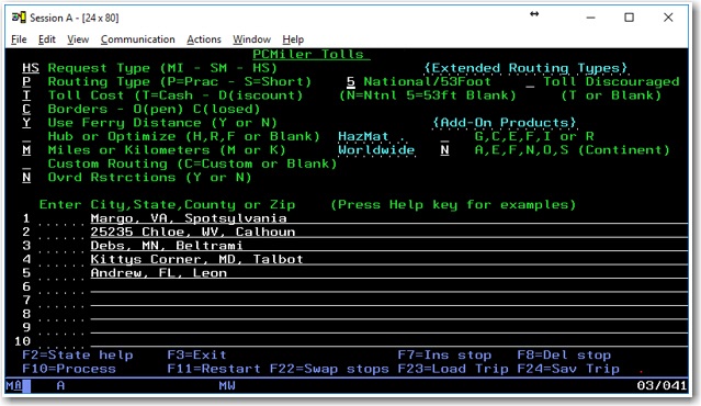
PCMTLL Main Screen
Control Settings at the Top of the Screen
Request Type
"MI", the default entry, will generate only point-to-point mileage look-ups. "SM" will generate a summary of miles traveled through each state, broken down by toll roads and free roads, in addition to the point-to-point mileage. "HS" will generate detailed driving instructions, in addition to the state mileage summary and point-to-point mileage look-up.
Routing Type
Either Practical or Shortest routing can now be combined with other available PC*MILER routing options (Toll Discouraged, National Network, or 53' Trailer or Twins). You must specify either P (Practical) or S (Shortest) for all routes. Learn more about PC*MILER Route Types.
Toll Cost
(Only with PC*MILER|Tolls installed) “T” will generate the Cash cost of all tolls incurred on a trip. “D” will give the Discounted toll cost. You can set discount toll member programs in the PC*MILER desktop program on you PC Mileage Server. Depending on the request type used, you will get total toll costs for the entire trip, a state-by-state breakdown of toll costs, or the toll cost per leg of the trip. PC*MILER|Tolls calculates tolls for an 80,000 pound, 5-axle vehicle.
Toll Discouraged
"T" will generate miles which avoid long stretches of toll roads. You will receive either a Practical Toll Discouraged Route, or a Shortest Toll Discouraged Route depending on how you have your “Routing Type” set. Note that not all toll roads will be avoided; tolls are avoided where possible while still maintaining a reasonable and practical route.
National/53 Foot
Either "N" or “5” will generate miles calculated using the State + National Network which favors the US Federally designated National Network (primary Interstates with reasonable entry/egress points up to 1 mile off the Interstate) and state designated extensions to the National Network (additional highways and supporting roads any distance off the Interstate, as determined by individual states).
State + National Network (National Network or 53 Foot Trailer or Twins) will be generated using either the “Practical” or “Shortest” routing type. You can also combine State + National Network (National Network and 53 Foot Trailer or Twins) routing with the Toll Discouraged option. For example you can generate a “Practical/Toll Discouraged/National Network” route.
Custom Routing
“C” will use custom routing preferences (avoids and favors) set in PC*MILER. When this position is blank, routing preferences will be disabled.
Hub or Optimize
A blank space is the default entry and is used for standard PC*MILER routing. “H” is used to generate hub distances. "R" is used to initiate optimized route sequencing with the origin fixed and the remaining stops reordered. "F" is used to initiate route sequencing with both the origin and destination fixed and the remaining stops reordered.
Borders
“O” will open the borders and routes will cross International Borders to obtain the most efficient trip. “C” will close the borders and routes will only cross international borders if the trip has a stop in that country.
Ovrd (Override) Restrictions
In addition to the five basic PC*MILER route types, a Heavy and Light Vehicle routing option is now offered. When Ovrd Restrictions is set to “Y”, the Light Vehicle option is activated. With Light Vehicle routing active, truck-prohibited roads will always be avoided, but truck-restricted roads are considered for a route. (PC*MILER normally gives preference to Interstates, major highways, and major thru-roads where possible.)
With Ovrd Restrictions set to “N”, Heavy Vehicle routing is in effect, so both truck-prohibited and truck-restricted roads will be avoided. In addition, Heavy Vehicle routing takes nationwide 13' 6" height restrictions into account. A heavy vehicle is one weighing at least 80,000 pounds; a light vehicle weighs less than 80,000 pounds.
Miles/Kilometers
"M" will generate distances in miles. "K" will generate distances in kilometers.
Use Ferry Distance
If set to “Y”, distance traveled on ferries will be included in all distance totals. If set to “N” ferry distances are not included in totals. Note: Routes will still include ferry travel but this travel is not included in distance totals.
HazMat
(only with the PC*MILER|HazMat add-on data module installed) Types of hazardous material routing that can be generated are: “G” for General, “C” for Corrosive, “E” for explosive, “F” for Flammable, “I” for Inhalant, and “R” for Radioactive.
Region
Regions in which mileage can be generated are: “A” for Asia; “E” for Europe; “F” for Africa; “N” for North America; “O” for Oceania; or “S” for South America. (Regions outside North America require PC*MILER|Worldwide.)
TIP: FOR AN ON-SCREEN DISPLAY OF THESE DEFINITIONS, press the Help key on your keyboard. For Terminal Emulation sessions on PC’s, this is typically the Scroll Lock key or Right Mouse Click > Help.
Stop Entry Fields
The fields to enter stops along a route are in the middle of the screen.
Enter the city names and state abbreviations for the stop-off locations desired, their ZIP codes, or their latitude/longitude positions. You may enter up to 30 stop-offs.
PC*MILER|Streets
If PC*MILER|Streets is installed, you can enter an address directly after the city/state or ZIP code, separated by a semicolon (e.g. "Princeton, NJ; 457 North Harrison Street").
Canadian Postal Codes and SPLCs
You can also purchase separate add-on data modules for Canadian postal codes or SPLC codes.
A Canadian postal code is entered in the same manner as a ZIP code, but in the following format: L#L#L# or L#L<space> #L#. (e.g. “K7L 4E7”). A SPLC is a six- or nine-digit number, preceded by the letters ‘SPLC’ (e.g. “SPLC908601”).
